California Weather: Slow-Moving Storm to Bring Month's Worth of Rain, Unusually Low Temperatures
By Renee Duff
An atmospheric traffic jam is bringing a taste of winter to both the eastern and western United States during the first days of May.
As the Upper Midwest digs out from underneath an impressive late-season snow event and parts of the interior Northeast contend with spring snowflakes through the middle of the week, AccuWeather meteorologists say a cold, slow-moving storm on the opposite side of the country may leave California residents in a state of bewilderment.
Weather along the West Coast will remain active this week as a storm brings rain showers along with mountain snow, according to AccuWeather Long-Range Meteorologist Alex DaSilva.
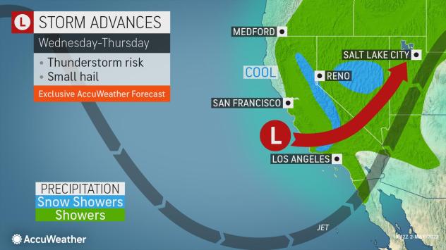
The storm had already begun its slow crawl inland by Tuesday morning as showers of rain and snow dampened northern and central portions of California. In Redding , temperatures were held in the 50s Fahrenheit Tuesday morning, mere days after the month of April ended with a stretch of 80- and 90-degree Fahrenheit weather.
The chilly, damp weather will sweep southward with the storm into Thursday, bringing unusual May rain to places such as Fresno , Los Angeles and San Diego . The historical average precipitation for May is less than 0.50 of an inch for each of these three cities.
Given how scarce precipitation typically is at this point in the year across the state, it is possible for this storm to unload a month's worth of rain in some locations.
Where these thunderstorms develop, AccuWeather meteorologists say torrential downpours can also occur, resulting in heavier precipitation amounts in localized areas.
Motorists will have to contend with unusually wet commutes for early May on either side of the day into the latter portion of the week. Reduced visibility from localized downpours can slow travel even further.
In addition to rain gear, people heading outside will want to ensure they wear some extra layers as chilly air accompanies the storm.
"Temperatures across California will be well below the historical average," DaSilva said.
Fresno, where the thermometer fell 3 degrees shy of hitting the century mark at the end of last week, will experience daytime temperatures in the 60s through the remainder of the week. Typically, by the end of the first week of May, the city's historical average high is around 80, putting this week's temperatures up to 15 degrees below that mark.
The cold air will result in snow accumulation across the high ground of the Sierra Nevada, as well as in the mountains of Southern California.
"Snow levels will drop to unusually low levels, perhaps as low as 4,000 feet. This could create some slippery travel through the passes, maybe even as low as the Grapevine along Interstate 5," AccuWeather Senior Meteorologist Heather Zehr said.
AccuWeather's team of long-range experts expects the first half of May to feature additional storms along the West Coast. A new storm this weekend is expected to bring more precipitation across parts of the Northwest and Northern California, as opposed to Central and Southern California.
"Near- to above-average precipitation can be expected from Northern California to the Pacific Northwest as a result during this time frame," DaSilva said. - AccuWeather