Iceland and the Mid-Atlantic Ridge
By Dr Khalid Siddiqui
Ohio

Earthquakes are produced by the movement of tectonic plates or by volcanic eruptions. But the formation of volcanoes itself is the result of tectonic activities. Plate Tectonics, therefore, is considered geology’s Theory of Everything.
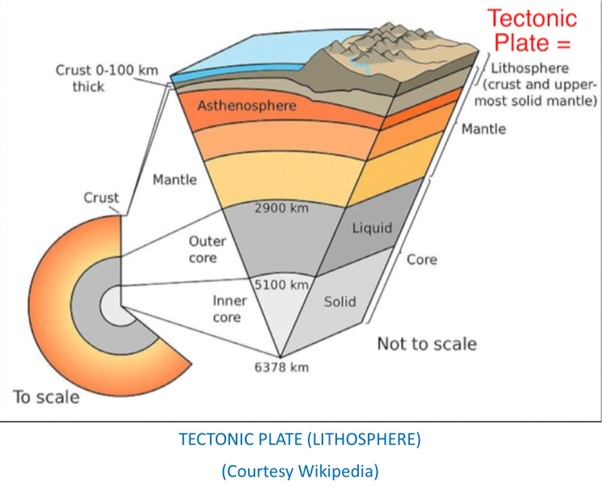
The earth has three layers which are, from outer to inner, crust, mantle and core. The crest is 9-12 miles deep on land (called continental) and 4 miles deep under the sea (called oceanic). Tectonic plates (also called lithosphere) are the pieces of the earth, consisting of crust plus superficial layer of the mantle.
Earth has seven major and many minor tectonic plates. These are fitted snugly against one another like a jigsaw puzzle but are unstable and have been floating on the mantle since 3–4 billion years ago. The vast majority of the world's active volcanoes are along the plate boundaries.
The edges of the tectonic plates (called tectonic boundaries) interact with each other in three ways:
1. Transform boundaries: The two plates while rubbing against each other get locked. That builds up potential energy. When finally, they break free the energy is released as tremors. In California, San Andreas Fault is a transform boundary where the North American and Pacific tectonic plates rub against each other. No volcano is formed here.
2. Convergent boundaries: Here the two tectonic plates bump into each other which, eventually, results in: (i) one plate going under the other plate (subduction) causing the other plate to rise up as mountains. The pressure and friction could cause the underlying solid mantle to melt and form magma. The magma shoots up resulting in the formation of a volcano.
(ii) Neither plate subducts under the other, leading to the buckling and uplifting of the crust to form mountains. The Himalayan mountain was formed as a result of the collision between the Indian Plate and Eurasian Plate which began 50 million years ago and continues to this day. No volcano is formed here.
3. Divergent boundaries: Here the two tectonic plates are moving away from each other. In the North Atlantic Ocean, the North American plate is moving away from the Eurasian plate at the rate of 2.5 cm per year. This wouldn’t have had much geological consequences except that the gap so created fell just under a hot spot in the Mantle. With the downward pressure of crust gone, the magma from the hot spot shot up forming a ridge called Mid-Atlantic Ridge under the sea around 16 to 18 million years ago. This ridge is a part of the longest mountain range in the world.
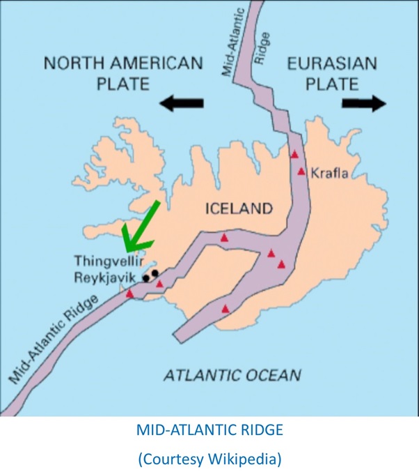
This ridge passes through the middle of Iceland. With continued upthrust of magma (the molten rock) several volcanoes were formed along the Ridge. Iceland has more than 100 volcanoes, 30 are still active. Also, with continued movement of the tectonic plates many fissures and geysers have been created throughout Iceland. Lava fields are scattered all over the country.
In Iceland, the Mid-Atlantic Ridge passes across the Pingvellir National Park (PNP), about 45 minutes’ drive from Reykjavik. It is the most popular tourist destination in Iceland with around 700,000 people visiting the park every year. Iceland is technically located on both continents because its western part is on the North American plate, while the eastern part is on the Eurasian plate. However, Iceland is officially considered part of Europe.
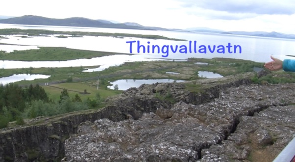
Above the ridge a rift valley runs between the two plates for nearly its entire length. Iceland is the only place in the world where this rift is above sea-level, and nowhere the edges of both plates are seen so clearly.
In summer, when the glaciers melt, the water flows down into these numerous fissures, and drops down in the rifts as waterfalls. Oxara river is one such river which descends to the rift in the PNP forming Oxararfoss waterfalls. In winter, the waterfall freezes, making it a popular destination for photography and ice climbing.
Pingvallavatn is a rift valley lake located within the PNP. It is the largest lake in Iceland. The underwater wells in the lake fill with meltwater from the Langjokull glacier. The water travelled underground for decades through porous lava rock, undergoing a very thorough filtration process. When it enters the lake, it is crystal clear. It is the purest drinking water on earth.
Silfa, a fissure in the northern part of the lake, is a popular scuba and snorkeling site. The visibility of the water within it exceeds a hundred meters, allowing visitors to witness the incredible geology beneath the surface. It is one of the world’s top five dive sites. The divers, however, must have dry suit certification.
The Hawaiian Islands are formed by volcanic activity as the Pacific Plate moves over a stationary hot spot in the Earth's mantle. The Pacific Plate moves in a northwesterly direction, which explains why the Hawaiian Islands form a chain, with the oldest islands located furthest northwest and the youngest islands directly over the hotspot.