USA TODAY
'Travel Could Become Impossible' as Powerful Winter Storm Dumps Snow in Sierra Nevada & Flood Watches Are Triggered in California
By John Bacon
A powerful winter storm crashing across the West on Sunday slammed parts of Southern California with more than 7 inches of rain and promised to snarl travel with feet of snow in some areas from the mountains of the Golden State through the Midwest.
The storm will continue across the West while "developing into a possible blizzard" in coming days, the National Weather Service warned. The system was forecast to sweep across a wide swath of the nation from Colorado to Minnesota on Monday through Wednesday, with driving snow, high winds and freezing rain.
"Heavy snow will bring major impacts to many areas across the country," the weather service warned. "Travel could become impossible."
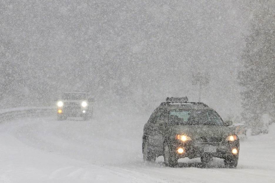
A stretch of California Highway 89 was closed because of heavy snow in the Lake Tahoe area, the highway patrol said. Parts of the Sierra Nevada could see 5 feet of snow and whiteout conditions Sunday and Monday, the weather service said. Parts of I-80 and other roads also saw periods of closure.
As the storm rolls east, AccuWeather said parts of I-90 and I-94, the major highways of the Upper Midwest, could be forced to close as the snow piles higher.
An atmospheric "bowling ball" could bring snow and a slight chance of thunderstorms to southwest California on Sunday, the weather service reported. The bowling ball is predicted to move across the northwest and southeast areas of the region Sunday night into early Monday.
The weather service reported heavy mountain snow in northeast California, the Greater Lake Tahoe region, western Nevada, and the Eastern Sierra Nevada.
Since Friday, the Greater Lake Tahoe region has seen up to 48 inches of snow, the weather service said. The weather service also warned of dangerous mountain travel conditions that will last until early Monday with 1 to 2 feet of additional snow possible in the Sierra Nevada above 4,500 feet.
In Southern California, parts of Ventura and San Luis Obispo counties were under siege from more than 7 inches of rain , the weather service reported. More than 4 inches swamped some areas of Los Angeles County, and localized rainfall rates of up to an inch an hour were drenching parts of southwestern California, with total rainfall reaching three inches in some areas.
Flash flooding and debris flow were a concern, particularly in and near recent areas burned by wildfires in the drought-stricken region.
The first band of heavy rain exited Los Angeles County shortly before 9 am PST Sunday but showers are expected through the day and overnight, according to the weather service. Scattered showers are also expected through Sunday in the Bay Area with a small chance of hail.
San Luis Obispo County saw "very heavy downpours" with strong wind gusts up to 80 mph Saturday night, the weather service reported. Multiple power lines fell Saturday night in the county causing all phone and 911 lines to be down, the Grover Beach Police Department said.
Nearly 30,000 customers were without power Saturday night, according to PG&E. By Sunday afternoon, most of the power had been restored in the county but more than 7,500 customers were still without electricity, according to PG&E's outage center map .
The National Weather Service was warning of possible severe weather Tuesday and Wednesday in Arkansas, Louisiana, Mississippi and Texas. Severe thunderstorms will be capable of producing tornadoes, damaging winds and hail, the weather service said.
'Major' snowstorm forecast from Colorado to Minnesota
A strong low-pressure system forecast to form over Colorado and Kansas on Monday will pull moist air northward from the Gulf of Mexico, combining it with extremely cold air from the polar regions in Canada, AccuWeather meteorologist Thomas Geiger explained.
" A major snowstorm is in the cards from Colorado to Minnesota into midweek," he said.
The worst of the storm could hit late Tuesday into Wednesday, with snowfall rates as high as several inches per hour in some locations. Wind gusts could reach 60 mph, Geiger said.
"Blizzard conditions possible (for) portions of northeast Colorado late Monday night - Tuesday night," the weather service's Boulder officer tweeted. "Significant travel impacts, whiteouts, road closures & harsh livestock conditions will be possible."
Snow will continue to push eastward as the storm strengthens. Parts of Minnesota could see snow with an icy mix at times. Geiger warned that a 10th of an inch of ice can be hazardous.
Some areas will see heavy glaze of ice
"Across much of central and southern Minnesota, a heavy glaze of ice may be more impactful than the snow," Geiger said. Some areas of North and South Dakota that see only snow could see 2 feet of it, he said.
The storm could last all week, AccuWeather Meteorologist Lauren Hyde said. Still unclear: The impact it will have on the Northeast at week's end. But heavy snow and ice could be on the way, forecasters said. – USA TODAY